Colorado First: Ancient Secrets
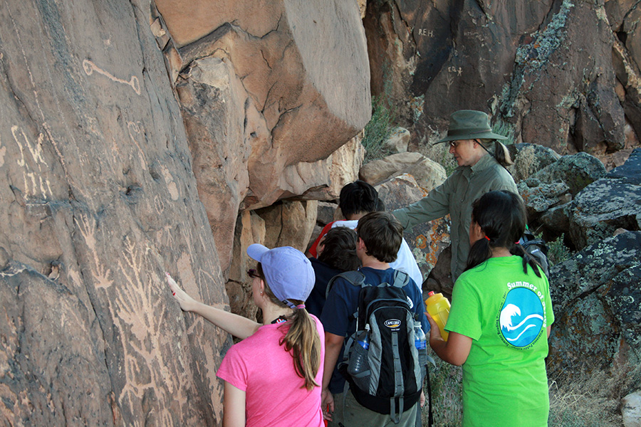
Archaeologist and petroglyph expert Carol Patterson, Ph.D., leads an educational summer tour of students from Telluride on-site at the Shavano Petroglyphs in Montrose County. © Lu Anne Tyrrell.
Ancient images carved into Colorado rock seem to hold profound secrets, their meaning hidden from easy interpretation. Even so, some experts offer their ideas, believing that the carved and painted images—of man, beast, the elements, or something otherworldly—depict events that have occurred, some that have not, or that have ceremonial purposes.
Lawrence Loendorf, Ph.D., of New Mexico State University, and of Sacred Sites Research in Albuquerque, says some works could represent “hunting magic”—that is, artwork designed to prophesize a successful hunt.
“An individual would sit at the rock and try to gain some knowledge about what might happen, like an oracle rock,” Loendorf said.
In conversations recorded in a new book, the late Northern Ute elder Clifford Duncan told a Montrose rock art expert and tour guide that Ute symbols cannot be understood without studying native culture, and how the symbols relate to one another (Patterson, Carol. Petroglyphs of Western Colorado and the Northern Ute Indian Reservation. Philadelphia: American Philosophical Society Press, 2016).
EnCompass spotlights four locations for rock-art viewing that span Colorado. Each spot is a singular adventure, from history and type of imagery, to accessibility.
Shavano Valley Petroglyph Park
Montrose
High above the agriculture of Shavano Valley is a rock art site sacred to Northern Utes, and dating back to prehistoric times. The late Clifford Duncan said the religious iconography found there is among the most important to Utes, depicting bear paw prints symbolic of the Bear Dance, the Sacred Tree, and the underworld trail that leads Ute souls to their creator, Sinauf.
In explaining the paw prints, Duncan said “a bear normally walks on all fours. But when there is something that a bear wants to see, it will stand up … That is why he leaves his prints on the wall, because he was standing up.”
The new life that comes with springtime brings a song, and a dance, to the bear, Duncan said. Patterson recalled that Duncan often said, in understanding the relationship between the bear and the Tree, “it is not the bear that’s important in bear dance, it’s the Tree. The bear only leads you to the Tree.” The Sacred Tree “represents vegetation and all things that grow.”
Shavano Valley is owned by the Archaeology Conservancy, and co-managed under the Black Canyon Trust. Sign up for a two-hour interpretive tour at the nearby Ute Indian Museum (17253 Chipeta Rd., 970-249-3098). Consider a morning tour, between 9 and 11 a.m., to avoid the summer heat. Bring water, wear sturdy shoes and a broad brimmed hat, and apply sunscreen.
Picture Canyon
Comanche National Grasslands
Not to be confused with its neighbor Picket Wire Canyon, Picture Canyon requires less of a time commitment than other sites. A short walk from the parking lot will take you to the rock art goodness in the free-to-visit canyon, near Springfield and very near the Oklahoma border in Baca County. More sinuous than geometric, Picture’s images include horses with graceful necks. Loendorf attributes horse and rider figures to the Comanches, and Pawnee for the warriors with spears.
The 2.6-mile hiking loop takes you past unusual rock formations, such as Balanced Rock, and the mysterious Crack Cave.
Access to Crack Cave is limited, blocked by an iron gate, locked to prevent people from further damaging what is already a vandalized space. The U.S. Forest Service opens the gate for spring and autumn equinox, the only days when the sun illuminates markings—hash marks—on the east-facing canyon wall for eight to 12 minutes. Historians can’t explain the markings’ origins. One widely read amateur sleuth, now deceased, speculated that the hash marks were etched by ancient Celts, in an Old Irish alphabet known as orgham—a theory that archeologists dismiss. What would be your interpretation?
Vandalism has left its mark throughout Picture, yet it’s just one of many sites in southeastern Colorado with abundant archeology. Carrizo Canyon, 25 miles to the west of Picture, with its pecked animal imagery, is one of many such destinations. Loendorf dates the work there to about 1100 Common Era (CE) by the Apishapa culture.
“The Purgatoire River Basin is spectacular,” Loendorf said. “People always go to the Four Corners, they go on the west side of the mountains in Colorado, and they don’t realize what’s down there.”
Dinosaur National Monument
Western Colorado and Eastern Utah
Some attractions require only a jog from the parking lot. While dino fossils get the most fanfare here, the collection of rock art includes both petroglyphs and pictographs, the latter of which is a rarity in the area.
The five main rock art sites are easy to moderate hikes from either a visitor center or a trailhead, with some requiring longer drives to reach the trailhead. Deluge Shelter and McKee Springs—pictographs and petroglyphs, respectively—both boast striking human figures adorned in jewelry or crowned by verticals suggesting hair.
“Some of the petroglyphs in Dinosaur are aligned in such a way that the sun touches them most directly on the day of a solstice or equinox,” according to A FalconGuide to Dinosaur National Monument (FalconGuides, Rowman & Littlefield: Lanham, MD, 2005). “Perhaps these drawings were used to signify the time to plant crops. Petroglyphs may also be an expression of what the designer would want to see. For instance, consider the couple holding hands at McKee Spring. Was this the day of their marriage?”
The Fremont peoples lived seasonally in the Dinosaur area between about 200 Before Common Era (BCE) to 1300 CE. Small bands or families hunted and gathered in the area, with some growing corn, beans and squash (aka, the three sisters). Various styles exist in the monument, most though are considered the “Classic Vernal Style” and consist of human figures with elaborate décor, as well as animal figures, some of which are easily identifiable, like bighorn sheep.
Dinosaur requires fees to enter the park.
Canyons of the Ancients
North of Mesa Verde, east of Hovenweep National Monument
No list would be complete without a visit to the archeologists’ playground in the southwest, with 6,000 sites to observe. Canyons is a backcountry experience—extensive hikes and high-clearance vehicles required—but the payoff is big.
The area has been peopled for at least 10,000 years, with pre-Puebloan Basketmakers migrating to the area about 1500 BCE. Over time, these Ancestral Puebloans became more reliant on agriculture, and built larger structures, eventually migrating away by 1300 CE.
Start any excursion with a stop at Monument HQ, the Anasazi Heritage Center located in Dolores. Maps, permanent exhibits and two 12th-century archeological sites available there will help you gain your bearings before heading into the backcountry. Remember though, Canyons is an “outdoor museum” and many of the sites aren’t marked, so “eye spy” is the name of the game.
You can count on some rock art at Painted Hand Pueblo, a village site from the 1200s, which features hands painted on a boulder next to a large stone tower. Look to high canyon walls for silhouetted red figures. For more archaeological attractions, the six-mile Sand Canyon trail takes you through the canyon floor past numerous pueblos and kivas.
Canyons requires fees to enter the park.
Tom Hess is Editor of EnCompass.